https://www.motherearthnews.com/natu...e-zmaz83mazraw
I have lived in NC my whole life and never knew anything about this place. I think I might try to find it soon.
Printable View
https://www.motherearthnews.com/natu...e-zmaz83mazraw
I have lived in NC my whole life and never knew anything about this place. I think I might try to find it soon.
Sounds like a fun trip/project/experiment.
The experience will be worth it even if any stones you find are not.
I found a layer of shale along the Mississippi around here that sounded like fun. It didn't work well and I think that that might have been because it was weathered. But I am not going to dig 10 feet into the side of a city park hill to find out if that makes a difference....:D
Haha yea good call. I'm not sure I'd be willing to dig 10 feet into my own property just to test a theory. Much less public land. I dunno when I'll be able to make it to the area where the quarry is, being that it's about three hours from home, but I definitely intend to take a trip out there. Hopefully I'll end up with something usable, even if it turns out to be a good mid range. I'd love to find a nice finisher and knowing it's a local abundant source and not just a fluke would make finding it that much better. I've found a few pieces that were interesting in the mountains, but always just miscellaneous stuff that could've come from anywhere.
That's been posted here before. This one's good too:
https://www.motherearthnews.com/natu...e-zmaz83mazraw
State by state guide of rock hunting possibilities.
If I remember correctly, the mine is about half way up the western side of McCauley mountain. There is a gravel road that will get you within about a 30 minute walk to mine and there is a good path to follow. I can't remember if the mine is on private land or if you have to cross private land to get to it, but we did get permission from an older gentleman up on the mountain to hike in there and get a few rocks. I probably have a map somewhere with the exact directions. I'll see if I can find it.
Two years ago I was at a flea market in the Neville Chapel area and there was guy that had some McCauley stones already cut and lapped for a sale at a reasonable price.
Oh, the stones that I have from there are comparable to an Arkansas Washita.
If you could find that map or maybe even post a screenshot of google maps in satellite view that would be fantastic. I don't know much about the area in question. I think the closest I've ever been to the area is probably I-40. I'd really like to get my hands on some of the rock uncut to get an idea of what constitutes a good hone throughout the process. I've found some interesting stones in the past but nothing that I'd put a razor on after it was lapped. This way, maybe I can save myself some trouble by knowing before it's finished that it isn't worth finishing.
Even if the stone is unusable for razors, it's really nice keeping your pocket and kitchen knives in shape on a stone that you picked from the ground.
I love these threads! I can't imagine anything more fun than "mining" your own stone and actually using it as well!
I'd base a holiday around it... but then, I have more time off than most. Either way, I'd love to mine and use one.
I've often wondered if there is anything worth going after in the flint hills.Quote:
Originally Posted by earcutter
I'll dig around this weekend and see if I can find the map.Quote:
Originally Posted by Krazymonkeys
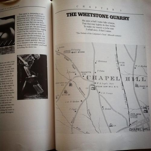
The article by Roy Underhill has some hints to the location in it, but it also has some misleading information in it - probably done on purpose to keep the quarry's location somewhat obscure. You can google earth the area though. McCauley mountain is just to the west of Chapel Hill, NC. On the east side of the mountain is University lake, on the west side, not a lot, but look for Neville Chapel.
I actually found an old map in another article and that points to a different area altogether. Pickard mill area which isn't even on McCauley mountain. That's what is confusing about the whole thing. All of the information is misleading, not just Roy Underhill. The bad part is satellite view of both areas didn't really show anything that looked out of the ordinary either.
Attachment 294202
To make it even worse.
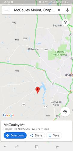
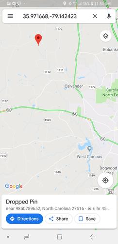
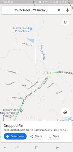
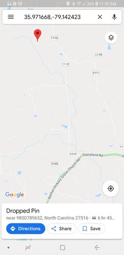
Yea that's basically the same map I saw. Here's some google maps screen shots of the areaAttachment 294203Attachment 294204Attachment 294205Attachment 294206
The first pic shows McCauley Mt. If you look at the map in the upper left it shows McCauley whetstone north of the two churches. In my other screen shots you can see hickory grove church and from what I can tell, Cane Creek road is now Dairyland Rd. That puts the quarry near Pickard Mill, not even close to the mountain.
Edit: actually, your map is a little different. Still the same area though. By Morgan creek. Attachment 294208
Why the Flint Hills? That's interesting!!Quote:
Originally Posted by bluesman7
It gets kind of confusing because everything has moved so the old map and new don't match up well at all. I will have to look again. I thought I had narrowed it down to a property and a house on a farm. You would have to ask them if you could search the hills and woods, but they may know and if they let you might point you in the right direction. I looked into this awhile back, but never got over there and forgot about it.http://tradingpath.org/pickard.pdf
I am planning a vacation in the Ouachita mountains of Arkansas. In my research the places I find are private or part of the National park. To find a place that you can legally pick a piece of novaculite off the ground sounds hard to find.Quote:
Originally Posted by earcutter
Sounds like there is a fair amount of Chert and Shale.:shrug:Quote:
Originally Posted by bluesman7
I'm 90% certain it was on McCauley mountain, but it was 10 years ago. There are small quarries all over the mountains, some dating back to before European settlement, so Pickard Mill area may be yet another quarry.
I emailed my friend that took me in there. I know that he knows where at least one of those quarries is at.
I did some research on the Chapel Hill site some time ago. As best I remember, the stream was maybe re-routed when a road was put through in the early 20th century, so later maps are probably better. You can also look at Google Earth and see quite a bit, and the satellite images are undoubtedly more accurate.
As far as the Ouachitas go, I think that it is a National Forest, not a National Park so you could I believe, go rockhounding with no issues, but it's always a safe thing to check. There's also novaculite in Georgia apparently.
Cheers, Steve
I also wonder what the quality of the slate we have around here is like. I'm a lot closer to the slate belt than I am to the Raleigh area. Maybe half an hour as opposed to 3 hours.
Look for old topographic maps. They usually show quarries and mine prospects right on them.
OK, it wasn't on McCauley mountain, it was called McCauley quarry and yes it is off of Dairyland road on privately held properly.
And the "old map" that Roy Underhill shows in the magazine article - well upwards on the map is not true north. So you have to rotate that map about 15 degrees to get the creeks and landmarks to line up. Still not too bad considering they did it on the ground with chains.
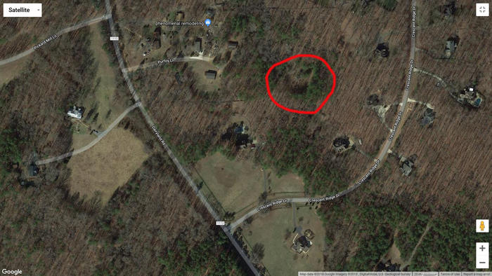
I'm attaching an image of the area with the whetstone quarry circled in red. Remember to get permission before going on the property and you might want to carry a sidearm, apparently coyotes are a problem in that area.
Attachment 294347
Thank you very much for this. It's going to make for a really cool road trip.