
Results 21 to 23 of 23
 37Likes
 LinkBack URL
 About LinkBacks
-
08-25-2018, 11:20 PM #21

Look for old topographic maps. They usually show quarries and mine prospects right on them.
No matter how many men you kill you can't kill your successor-Emperor Nero
-
The Following User Says Thank You to thebigspendur For This Useful Post:
32t (08-25-2018)
-
08-27-2018, 03:38 AM #22Senior Member


- Join Date
- May 2014
- Location
- Easley, SC, USA
- Posts
- 1,861
Thanked: 480
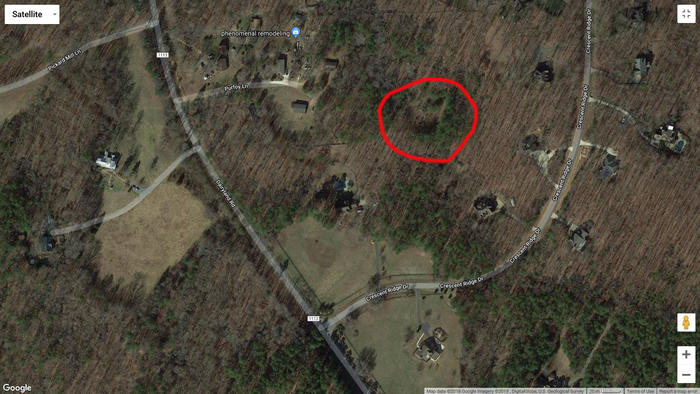
OK, it wasn't on McCauley mountain, it was called McCauley quarry and yes it is off of Dairyland road on privately held properly.
And the "old map" that Roy Underhill shows in the magazine article - well upwards on the map is not true north. So you have to rotate that map about 15 degrees to get the creeks and landmarks to line up. Still not too bad considering they did it on the ground with chains.
I'm attaching an image of the area with the whetstone quarry circled in red. Remember to get permission before going on the property and you might want to carry a sidearm, apparently coyotes are a problem in that area.
 Krazymonkeys likes this.Some people never go crazy. What truly horrible lives they must lead - Charles Bukowski
-
The Following User Says Thank You to criswilson10 For This Useful Post:
Krazymonkeys (08-27-2018)
-
08-27-2018, 07:04 AM #23Junior Member
- Join Date
- Aug 2018
- Posts
- 20
Thanked: 6
Thank you very much for this. It's going to make for a really cool road trip.


 Reply With Quote